When the glaciers of the last ice age retreated, they left a ragged coastline of what is now the state of Maine in America’s farthest northeastern reach. So rough is this resulting geological feature that the Maine coast measures second in length only to Alaska’s. It is ten times as long as the Oregon coastline and longer than the rest of the eastern seaboard coastline combined.
Granite and basalt comprise the majority of the coast’s rock formations, interspersed with many areas of wavy metamorphic slabs and boulders. In addition, approximately four thousand islands dot the scene just offshore. Together with the numerous bays, coves, inlets, and coastal mountains, they form a paradise for outdoor enthusiasts. In western Maine, you’ll find downhill skiing, lake and stream recreation, and hiking (including the famous iconic Appalachian Trail).
With good reason, most visitors to Maine’s coast make their way to the spectacular vistas and beautifully maintained trails of Acadia National Park on Mt. Desert Island. But, while Acadia deserves its status as the jewel in Maine’s coastline crown, it is not the only place to enjoy the scenic splendor of this beautiful corner of America.
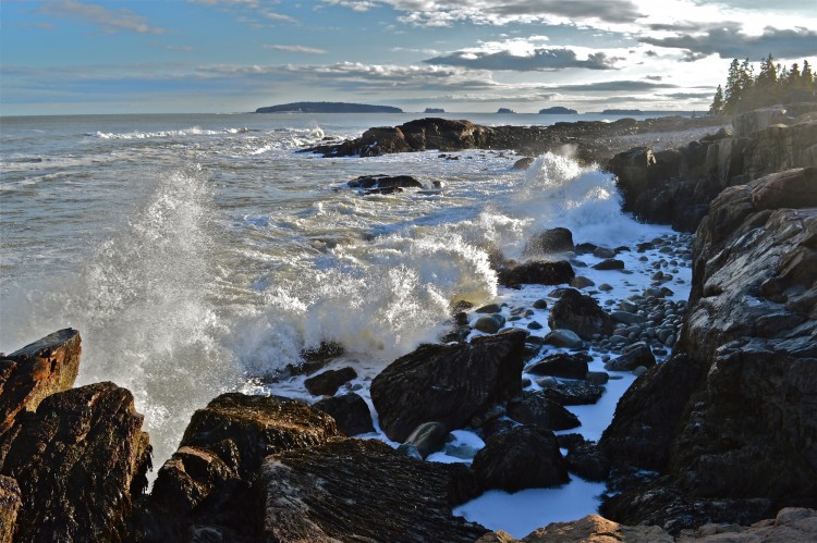
Maine’s coastline provides dramatic surf. Photo: John Stiles
Some of the links in this article may contain affiliate links. When you purchase using these links, part of the proceeds go to Snowshoe Mag. Additionally, as an Amazon Associate, we earn from qualifying purchases. Please see our disclosure for more details.
About the Blue Hill Peninsula
Just beyond Mt. Desert Island, in either direction up and down the coast, lie numerous preserves, sanctuaries, and parks. A quiet hike awaits among towering pines, marshes, meadows, and shoreline. One such place is the Blue Hill Peninsula, about 30 miles southwest of Acadia.
The Blue Hill Peninsula is between Penobscot and Frenchman Bays and includes the towns of Blue Hill, Brooklin, Brooksville, Castine, Penobscot, Sedgwick, and Surry. Its iconic coastal villages draw artists, musicians, and writers from around the world. The artists have put down roots alongside local fishers, lobster and scallop harvesters, boat builders, shopkeepers, and farmers. The main town of Blue Hill has quaint shops and restaurants, many open year-round.
The local and summer residents of the Blue Hill Peninsula and two nearby islands, Little Deer Isle and Deer Isle, value the natural surroundings and have strived to protect them. They have offered access to maintained trails through varying landscapes, including riverbanks, mountains, mixed deciduous and coniferous forests, wild blueberry barrens, marshes, and the Atlantic coastline.
Two conservation organizations, the Blue Hill Heritage Trust and Maine Coast Heritage Trust, have conserved over 150,000 acres to protect wilderness and wildlife and offer recreational opportunities on trails and waters. In total, in the Blue Hill area, these groups maintain over 20 preserves and trails.
Nearly all of the preserves prohibit motorized vehicles. But some are open to hunting, mainly in November. Use caution and wear flame orange if venturing out during this month. You can access these preserves at any time of year. However, winter hiking is especially beautiful.
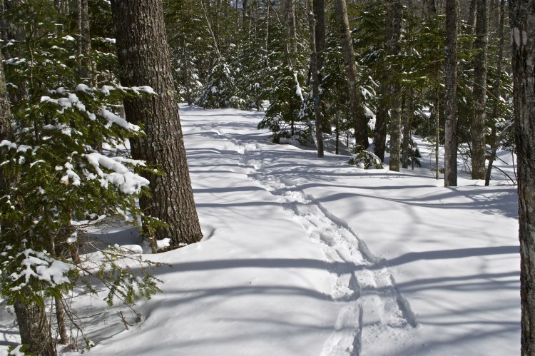
The peaceful trails at Patten Stream are ideal for snowshoeing. Photo: John Stiles
Patten Stream Preserve
Typical of the recreational areas is Patten’s Stream, a Heritage Trust-maintained conservation trail in the coastal village of Surry, about halfway between Blue Hill and Ellsworth on state highway 172. (From Bar Harbor and Mount Desert Island, follow Rt 1A to Ellsworth, then Rt 1 toward Belfast, bearing left on 172 as you leave Main Street).
I snowshoed the trail after a lovely two-inch layer of fresh snow covered the already three feet of accumulation, which was unusual for the time of year. The day was cold (19 degrees F, -7 C) but sunny. Driving to Surry, I took Warren Road about a quarter-mile (400 meters) to what is usually the parking area, but due to the deep snow, it was closed. So I returned to the main road, parked at the Town Hall, and then walked back to the trailhead.
About the Preserve
The trail consists of two loops connected by a spur trail. Both follow the tumbling water of Patten Stream before looping back away from the water. They pass through a mixed forest dominated by pine, spruce, hemlock, and balsam fir, with a scattering of large birches, oaks, and maples.
I was the only person to use the trail that day. So the path was unmarred by footprints, except for those of deer, fox, squirrel, and, to my surprise, otter. The trail is rather uneven, with several short, steep sections and tight turns. This setup makes it difficult, if not impossible, for cross-country skis.
The snow was too deep that day for hiking (I removed my snowshoes to check and sank up to my thighs), and the snow hung heavy on the boughs of the evergreens, bending those of young trees to the ground. The only sound was the nearby stream and my shoes plunking into the soft snow cover. It is a perfect snowshoe trail for beginners, but experienced enthusiasts will find its scenery worth the trek.
The entire hike I took through the Patten Stream Trail was about three hours. Of course, it depends on how often one stops to survey or snap photos of the scenery (I spend a lot of time). I tend to observe the up-close beauty of the natural environment, sit on a boulder, and enjoy the view along the stream. The time on the trail also depends on whether there is snow and how deep it is.
A caution: Even if hiking in winter, and if the weather is mild (above freezing), it is advisable to use insect repellant (like this safe, natural replica). Insect repellent discourages the remaining hardy wood ticks that have survived the cold.
Wildlife Abounds
Many forms of wildlife live in and near the conservation area and trails at Patten Stream. Ospreys nest close by and fish for alewives. Otters (I now know) hunt for fish and make dens on the river bank, and numerous deer and foxes crisscross the area. Songbirds and woodpeckers can be seen and heard as well.
As I paused to admire the beauty of the woods and stream, it was not difficult to imagine that I was the only person who had walked along the trail for days, perhaps weeks. Indeed, I knew I was the only one so far that day. Yet, the stillness and knowledge that I was alone in that beautiful spot were exhilarating.
As I scanned the area, I caught sight of a strange trail. It began on one side of a pool, ascended steeply from the water, and across the snowy boulder to the far side. Then, it went down to the water not as tracks but as a long, smooth “slide.” I was temporarily confused until I realized that the only creature that could make such a track was a river otter. The slide was the tip-off. I waited for some time to see if the aquatic mammal would show itself, as the track was fresh, but it did not reappear.
Despite my disappointment of not seeing the otter, I was content to have at least seen the track and know they were there. As I sat overlooking the stream, I was surprised by the flutter of wings. A male mallard emerged from the next pool, out of sight behind the rim. But, I must have also been a surprise to him. He took wing after realizing I was there, rushing past me toward the bay.
Read More: A New Found Passion: Wildlife Tracking and Identification
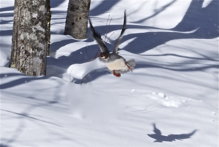
A startled mallard takes wing. Photo: John Stiles
Gorgeous Scenery
After a few hundred yards, the trail met the stream I had seen from the top of the ravine as I walked. The scene was breathtaking. The huge glacial boulders in and alongside the stream were covered with pristine snow. Moreover, the stream was frozen in many places, on which the soft covering made a continuous rolling blanket of white. Interspersed were open spaces where the icy stream rushed through the ice covering. The stream was completely different now from the autumn when I was last there, rushing and tumbling freely over rocks and around boulders. Now, it was all but hidden, with what seemed like a series of small unconnected pools.
Reluctant to leave the beautiful spot, I headed toward the north loop. This loop continues along Patten Stream to a flat rock at the trail’s end. Here, the divided stream meanders quickly past boulders, rejoining past the rock on its journey to the bay not far away. Walking through the forest, one can continue on the “outer” side of the two loops. Or, you can retrace the path along the river. I chose to backtrack because of the stream’s beauty.
Read More: 8 Reasons Why Winter Hiking Rocks
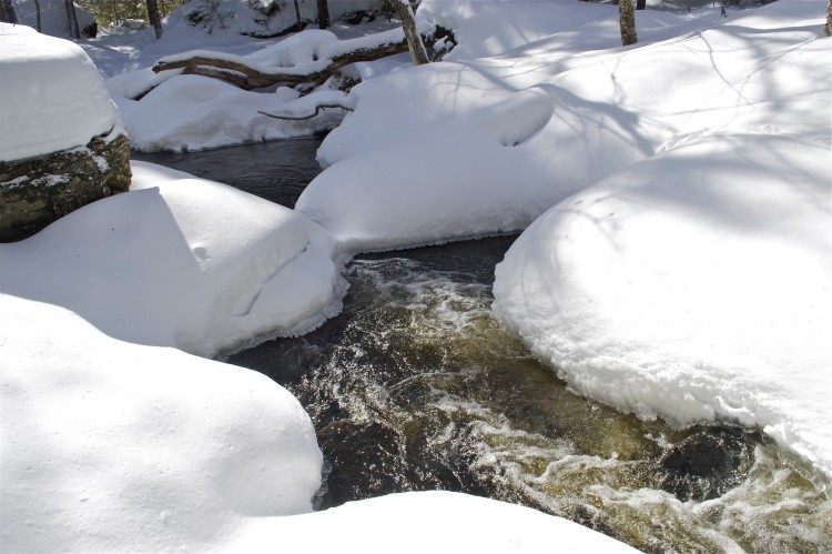
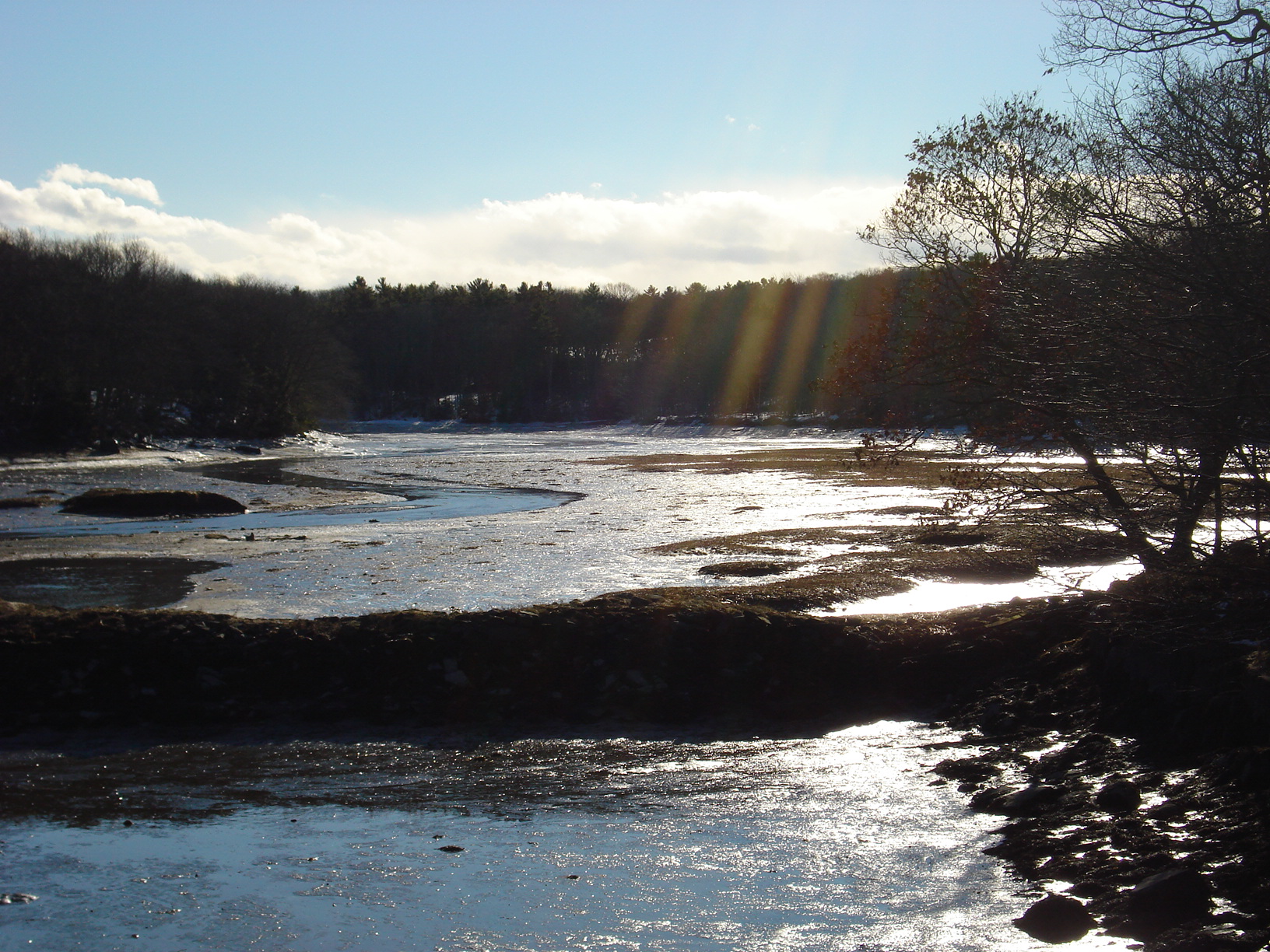
Patten Stream is on its way to a nearby bay of the Atlantic. Photo: John Stiles
Other Trails at Blue Hill Peninsula
Patten Stream and the other trails on the Blue Hill Peninsula offer quieter, less crowded hikes than the popular ones in the national park. Moreover, they have a subtle beauty all their own.
If you are in the area, take a day or two to explore the trails on the Blue Hill Peninsula. They are well maintained by the trusts and are a well-kept secret among the locals who love to enjoy them in all seasons.
Here are a few other areas to visit:
Cooper Farm at Caterpillar Hill
Located in Sedgwick, this scenic and cultural landmark at Caterpillar Hill offers beautiful views via three main loops. Experience a diversity of landscapes. The upper trails pass through expansive fields (with blueberries in summer). Alternatively, the lower routes take you through a mossy forest.
Each loop is a short 0.25 to 0.7 miles (0.4 to 1.1 km). Or, for a slightly longer outing, you can hike, ski, or snowshoe the outer loop at Cooper Farm at Caterpillar Hill, which is a total of 1.5 miles (2.4 km).
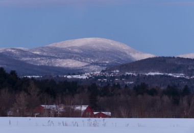
Blue Hill Mountain
One of the most popular hikes in any season is Blue Hill Mountain, located on the north side of Mountain Road, one mile north of Blue Hill Village. The ancient volcanic peak dominates the local skyline, visible for several miles. Rising to 934 feet (385 meters) from Blue Hill Harbor, this preserved area has seven trails (over 4.5 miles /7.2 km). The trails wind through meadows and mixed hardwood, spruce, and pine forests.
The one-mile (1.6 km) combined service road and Hayes Trail is a moderate climb. Thus, it takes from 40-60 minutes on snowshoes. I took slightly over an hour, stopping to rest occasionally, admire the scenery, and take numerous photographs. At the summit is a clearing with a sweeping view of the many offshore islands and Blue Hill Bay.
Read More: Snowshoeing Blue Hill Mountain on the Maine Coast
Meadow Brook – Mill Stream Conservation Area
The Meadow Brook – Mill Stream Conservation Area offers a short 1/3-mile (0.5 km) trail if you’re looking for a quick jaunt into nature. This trail meanders along a 6-foot wide gravel path with two easy-moderate inclines. You’ll be met at the end with an open view of the stream.
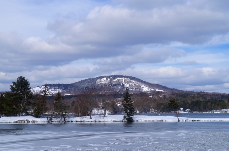
Blue Hill Mountain rises from Blue Hill Harbor on Maine’s Down East coast. Photo: John Stiles
Area Info
Once finished with the trails for the day, one may wish to return to Blue Hill. Try a refreshing drink in one of its pubs or restaurants. Or you can browse the open art galleries, bookstores, and gift shops year-round or go to Ellsworth. The area’s main town is in the opposite direction on the way to Acadia. Here, there are many shops and restaurants as well.
For maps of the various protected trails, islands, and water access points, visit the Blue Hill Heritage Trust trails info.
This article was first published on April 20, 2015, and updated with additional trail info on June 30, 2022. The most recent update was November 10, 2023.
Read Next: Maine Snowshoe Trails: Acadia National Park Area
Maine is a gorgeous state.